Tuesday, October 10, 2017


Friday, Oct 6, we drove from northern Utah to Salmon, Idaho.  We were surprised to see how high the rivers and reservoirs were.  This was due to heavy snowfall last winter in Idaho.  The Lemhi River was full and beautiful, as was the Salmon River.  The Salmon River in the town of Salmon overflowed and did some damage around the island downtown.  The RV park where we stayed was on this river, and the damage could be seen from there.  It was nevertheless beautiful to look at and hear the river flowing full as we stayed there.  Friday night the Sundbergs had us over for dinner along with another old friend of Betty, Gladys Goodman.  After dinner we watched an excellent movie on TV, Hidden Figures, about black women working in the NASA program during the early 1960s.  Saturday the Sundbergs drove us around scenic areas of Salmon to hike and observe the fall colors.  Sunday we attended church at Betty's former church, Shepherd of the Valley Luthern Church, where Betty fellowshipped with old friends.  On Sunday afternoon, Betty multitasked by doing laundry and receiving guests.  Old friends came by and talked a long time.  Monday morning Betty did aerobics with friends, went shopping, and got her hair done by her old hairdresser.  I worked on the motorhome, spending a long time getting insect remains cleaned off.  The bugs on our ride through southern Idaho were small but numerous, so much so that a thick paste of their remains covered not only the windshield, but also the front of the motorhome and the fronts of the two side mirrors.  I also got replacement light bulbs for outdoor lights that had gone out.  I also found some time to work on photographs, but not nearly enough.  Monday night we again had dinner at the Sundbergs, after which we watched another excellent movie, The Lake House.  Then Betty sadly pulled herself away from her dear friends of so many years.  The Sundbergs have been like brother and sister to her.  As we drove away this morning, Tuesday, Betty shot 20 videos along the trip from Salmon to Livingston.  It will take time to process through all that.  Livingston, Montana is up the road north of the north entrance to Yellowstone National Park.  When I naively set up this trip, I knew nothing of how much longer it takes to drive on mountain roads, nor did I realize how much slower one must travel in a motorhome than in a car.  As a result, based upon my limited experience in Florida and the Southeast, I planned daily drives that leave little time after arrival.  I had assumed that we would have time this afternoon to drive down to Yellowstone and back before dark.  Not so.  Hopefully I plan better next time.  As it is, we have reservations tomorrow in Miles City, Montana, an even longer drive than the one today.  The significant difference will be that tomorrow will have very little, if any, in the way of mountain roads.  It will be all on I-90 and I-94.

View along road approaching Salmon from the south

View of river from above Salmon
Our place in RV park along Salmon River

Another view of our site in RV park along river

Deer waiting when we returned from Sundbergs Friday night

Mountains behind Salmon High School

Our site at beautiful Livingston KOA park
View leaving Livingston KOA.  Looks like a Swiss dairy farm.

Thursday, October 5, 2017

On Monday, October 2nd, we visited Canyon de Chelly National Monument, over 2 hours drive to the southeast in northeast Arizona.  This was truly a journey into the middle of nowhere, passing through desolate regions on a lonely road until reaching the town of Chinle on Indian Road 7.  There was a lot of road work being done in the national monument, so we missed some portions that were closed.  The winds were the worst experienced so far, enough to blow a grown man off his feet.  That, combined with the sheer cliffs in this area, made the visit a little more intense than we would have liked.  We did get some nice photos, but the only cliff dwellings here are far down into gorges that can only be photographed with a long lens.  You are not allowed to enter any cliff dwellings.  There even was a set of dwellings far down into a gorge where native Americans continue to farm just as their ancestors did in that area.  The farther one goes down into the gorge, the less the wind.  No wonder the natives preferred to live in the gorges.  A local Navajo said that the winds are always strong there, especially in the spring.  I said that I was glad that it was not spring.  Along the roads that one drives to arrive at the overlooks into the gorges are homes and ranches where ancestors of the ancient cliff dwellers continue to live.  All this is interesting, but the very limited number of cliff dwellings and their inaccessibility make this national monument of less interest than a place like Mesa Verde National Park.  It was a long drive there and back through a dismal area to gain so little.  Perhaps if there had not been so many closed areas it would have been a more satisfying visit, but in the end it was just tiring.

On Tuesday, October 3rd, we drove to the Moab Rim RV Park in Moab, Utah.  This was about a mile away from the RV park we stayed in with the tour.  We spent the afternoon on housework like laundry, shopping, and working on organizing photos and videos taken over the prior several days.

On Wednesday, October 4th, we visited the Hole in the Rock along Rt 191 south of Moab.  This appears from the road to be  tourist trap, and to some extent has turned into that.  The current owners have a zoo and things like old motel signs scattered over the property.  The central item, however, continues to be the item of significance.  Albert Christensen was a uranium miner (among other things) who used his mining experience to enlarge the cowboy cave in the side of a large rock into a 5,000 square foot home and diner, which now is a store and museum.  The skill with which he blew out and chiseled out rock to make a very comfortable home is worth the $6.50 price for a 12 minute tour.  The year-round temperature inside is a comfortable 70s.  I am surprised that more is not heard about this place.  After this visit, we moved on south to the The Needles District of  Canyonlands National Park.   This was a long drive south from Moab, then a 30+ mile drive from Rt 191 west to the park.  At first the drive is somewhat featureless, then toward the end there are large rock formations like those in other nearby national parks and monuments.  We got some interesting photos, but the four hour hike of the Cave Spring Loop was the most memorable event of the day.  Betty insisted on climbing the two ladders, scrambling over the rocks, walking the trails up on the rock plateau, then climbing down the other side and proceeding along a trail under rock ledges to complete the hike.  She really feels it today.  We did part of it twice, since the top of the first ladder on one side stopped at a wide crevice that Betty did not want to cross, so we went back down and nearly returned to our Jeep.  Then we saw the other end of the loop that led to the other side of the plateau, with another ladder that one descends to lead back to the parking lot.  We decided to hike the trail backward to see the other side.  There we climbed the ladder and went up the ledges and steps to the top of the plateau.  From there we walked the trail backward to the crevice that Betty avoided at first, but now she bravely crossed it backward, descended the original stairways, and hiked the first trail back to the Jeep.  So, she hiked the first part of the trail and climbed the first two ladders twice, once going up and then going down.  Not bad for a lady scheduled to have hip replacement surgery next month.

The green area is where the cave water spring is located
A long trail under rock ledges leads to the spring
Betty perseveres with her bad hip

Trail proceeds over high rock plateau to continue the loop

Cowboy cave along trail near parking lot
 Today, Thursday, October 5th, we drove from Moab to west of Ogden, Utah.  We are staying at the Century RV Park.  It is right on I-15 and a bit noisy.  The best part of the slot that we have is that we are able to leave the Jeep hooked up overnight, allowing us to have one less duty in the morning before we leave.

Sunday, October 1, 2017

We got up early in order to attend church in Kayenta, about 25 miles away.  Kayenta is a small town of trailers and similar buildings set on red clay hills.  The roads are very bad and the neighborhoods very disorganized. It is difficult to find things to begin with, but following a GPS to find something in this place is a new experience.  We followed the GPS into a rugged and hilly area but found no First Baptist Church, which was the nearest to the kind of evangelical church we wanted to attend.  In the general area was a building that looked like a church, but the gate was only half open and there were no cars there.  I walked up the hill to the church only to find that it was a PCUSA Presbyterian church.  I opened the doors and looked in.  No one was there to greet people.  I looked inside the sanctuary to find a woman Navajo in the pulpit singing a hymn in Navajo to two Navajo women in the pews.  To the other side there was a white couple who sat motionless.  The leader was very enthusiastic in trying to get more singing to come from this small group, but the prospects were slim.  I went back to the car to explain to Betty what I had found.  We then drove around the immediate area to see if the GPS was just a little off.  We then widened the circle of search finding no cars anywhere.  We drove to a school where we found a pickup truck about to leave.  We asked the Navajo driver where the First Baptist Church was, but she had no idea.  We saw a Catholic church with the gate locked and no cars present.  We decided to drive back to Monument Valley.  Along the way we saw a pentecostal church with the parking lot full.  That was not our cup of tea, so we continued back to the RV park.  Along the way back on Monument Valley Road, I pulled over to photograph the spot in the film where Forrest Gump stopped running.  I did not stand in the middle of the road (as many foreigners do at their great risk, since drivers go at break-neck speed) but did get a couple interesting shots with my phone.  Since the phone easily loads to the computer, I have included the photos here.  We also stopped for gas at the gas station at the foot of the hill leading to the RV park.  I took a photo of its location and the sticker on the pump that explains that you are in the Navajo Nation and pay taxes accordingly.

Where most of the tourists thought Forrest Gump quit running
On a hazy day I shot Rt 163 from the north (opposite side) which is what appears in the movie

Sunset at Monument Valley

Gas station just before RV park up the hill

Sticker on gas pump at above gas station
Sunday afternoon we drove to Valley of the Gods, a place mentioned by the RV tour but skipped due to the difficulty of driving into the valley for a bus.  We drove there in the Jeep and truly needed it, especially when we followed Betty's GPS which took us on a very rough road to nowhere.  The actual valley was in a different place, so we went back up the rough road and took the not-quite-so-rough road to the real valley.  This is another place like so many in the Southwest where a Western movie could easily be filmed. 

Saturday, September 30, 2017


The motorhome tour is over.  We left the Grand Canyon Camper Village RV park this morning after an 8-9 am breakfast outside the wagonmaster's motorhome.  We had blueberry muffins, cinnamon rolls, Greek yogurt, oranges/tangerines, juice, and coffee.  Many passed out business cards and we gave our blog/web site card in return.  There were some warm displays of affection and hugs exchanged.  After getting our hookups disconnected and hitching up our Jeep, we reentered the Grand Canyon National Park northward, then turned east to drive Rt 64 eastward back to Cameron where we ate lunch.  After lunch we made the return trip to Monument Valley and set up in the Goulding Campground.  We have a full hookup 50 amp pull-through slot with an amazing background of rock formations.  We then drove to the visitor center to attempt a good sunset photo, but the sun sets on the opposite side of the mittens, so we shot the last light on them.  It would be quite a trip to get to the other side of the mittens to see the sun set behind them.  Tomorrow we plan to attend church in Kayenta, then after lunch visit the Valley of the Gods (part of Bears Ears National Monument) and perhaps also Navajo National Monument.  On Monday we hope to see more of Monument Valley and perhaps also Canyon de Chelly.  Sounds like a lot, and hopefully we can fit it all in.

Our site at Goulding Campground 

Friday, September 29, 2017

On Sunday the 24th, we drove from north of Durango to the Cottonwood RV Park in Bluff, UT.  Along the way we stopped off at the Four Corners.  This is where the corners of Utah, Arizona, Colorado, and New Mexico intersect.  I saw this 11 years ago as a concrete slab with medallions embedded, a few flags, etc and little more.  Now the Navajo Nation has exercised its authority to surround it with a perimeter of stone booths for selling native American artifacts to a captive audience.  They also charge an entry fee, since the area is now fenced off from the public.  Betty bought some things, and I took some photos.  Getting there, as with all things in the Navajo Nation, is on a long bumpy and dusty road.  The roads are not maintained; they simply put up a sign saying "ROUGH ROAD."  The parking area was a large rough and rocky area not well suited for parking a motorhome pulling a car behind it.  Getting in and out was interesting.

Wide view of Four Corner grounds

Betty standing at intersection of four states

Sand paintings exhibit

Closeup of sand paintings
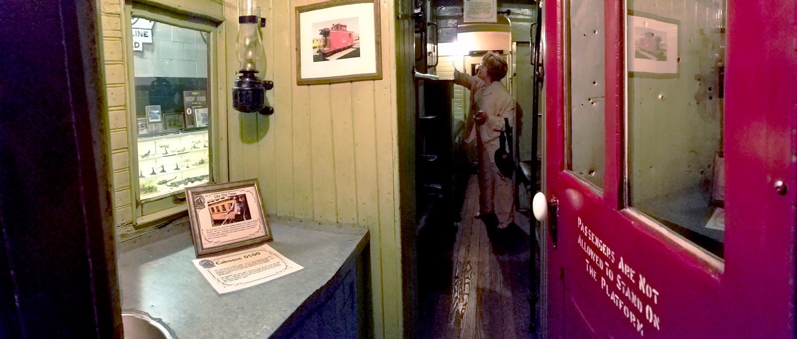
Arriving in Bluff was easy enough, with a simple but adequate RV park.  Our tour filled the park.  The area is very isolated, with few stores other than what caters to tourists.  And there are very many tourists.  At a trading post the man there told us that two filming crews were in town to shoot commercials.  One was a German company filming a car commercial.  The other was a Japanese company filming a cigarette commercial.  This demonstrates that you do not have to go to Monument Valley or Moab to film dramatic cliffs and other large rock formations.  The high country of the Southwest pretty much looks like that when you get to the cliff areas.  We also got a tour of Bluff Fort, a Mormon outpost established by determined pioneers who were willing to face the seemingly impossible task of crossing the territory full of extreme cliff ridges.  We watched a reenactment film showing horse-drawn wagons with ropes tied behind being eased down steep declines to form a rocky road through the ridges, often blasting through large rock faces using black powder.  As a non-Mormon, I cannot fathom what motivated them to have such a faithful missionary spirit under such dire conditions.  They have a museum maintained by direct descendants, with cabins built by these ancestors maintained by relatives here today.  It is almost a nationality here to be Mormon, much as being an Irish or Italian Catholic gives many a sense of identity.  By the way, it was NOT Ft Bluff; only military bases have the prefix "fort."

The next morning, Monday, at 7:30 am we boarded a bus for the trip to Monument Valley.  There we were in an area of the Navajo Nation (not a national park) where we could take photos of the much-photographed monuments of stone.  To see a quick overview video of Monument Valley, click here:  Quick Overview of Monument Valley.  It was a very dusty area.  How on earth did Hollywood film crews keep their 1930s equipment in working order with all that wind and dust?  For that matter, how do you do it now?  We then were loaded up into the backs of four trucks equipped with seats for a ride through the valley.  Again, driven by a Navajo driver who loves fast, dusty, and bouncy rides.  Try taking photos under those conditions.  I decided to use only a small video camera, which managed to produce surprisingly good movies of the experience.  We were let off a few times for photos, when we all made as much use as we could of existing light once the dust settled.  A video of the truck tour can be seen here:  Navajo Monument Valley Truck Tour.  It is only a few minutes long.

Betty poses with horse while on Navajo truck tour
After that we had lunch and visited the film museum, focusing mostly on John Wayne.  We saw the cabin that appeared in the film, She Wore a Yellow Ribbon.  I had my photo taken sitting inside and in the driver seat of a stagecoach.  We then went to Goosenecks State Park and got good photos.  This was another example where many state parks are about as impressive as their famous national park counterparts.  I have mentioned goosenecks earlier, since these rock shapes appear in several areas, but this is a state park named for them.

Door of cabin John Wayne used in She Wore a Yellow Ribbon

John Wayne Cabin, used in She Wore a Yellow Ribbon

Inside the John Wayne Museum

Inside the John Wayne Cabin

Steven seated in stagecoach outside John Wayne Museum
Interior of old stagecoach.  Not much room.

Goosenecks State Park
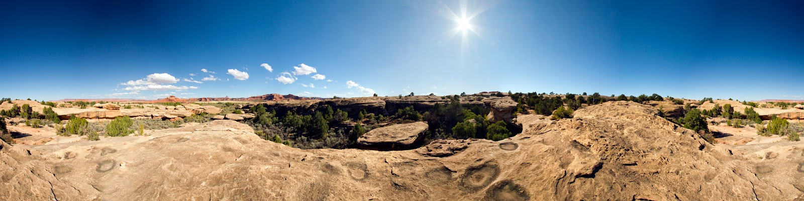
The next morning, Tuesday, at 7:30 am we again boarded a bus, this time for Natural Bridges National Monument.  We took a long hike into this area for some good photo opps.  Then we returned to the RV park to get lunch.  We then went to nearby Bluff Fort (this is when we saw the film and got a tour of the fort site).

Example of one Natural Bridges National Monument formation
Wednesday morning early we departed for the Grand Canyon Camper Village, south of the South Entrance Station of the south rim of the Grand Canyon.  It was a typical drive through the Navajo Nation, with  many rock formations that make you wonder if you should stop for yet another photo session.  The weather was windy with threatening rain.  We stopped for lunch in the town of Cameron, east of the park on Rt 64.  It was nice to find a place in the middle of nowhere that had gas stations and places to eat.  We re-fueled and ate at a Burger King.  We then continued on our way west on Rt 64 to the south rim.  As we entered the park, we saw a sign reading "First View of the Grand Canyon."  There was no place to pull over, so all you could do was glance to the right as the trees opened to see a fabulous sight.  The sun was out at that point and the visibility was good.

As we struggled to get set up in the tiny and primitive RV park south of the national park entrance, the wind picked up and the rain began.  We were dressed in layers of clothes to keep warm and dry, with the top layer being a yellow rain slicker with hood.  As we drove back into the national park that afternoon to see as much as we could before supper, the sun came out beautifully, and we wished we had brought more than just our phones for taking photos.  As we were driving down Desert View Drive, a herd of female elk crossed the road in front of the car in front of us.  A short video of it can be seen here:  Herd of female elk crossing Desert View Drive.  The sun in this part of the country continues to be very warm and blindingly bright.  We took a few photos with our phone near the east rim, then hurried on back to the RV Park for a group pizza dinner at a nearby restaurant.

Thursday morning early we boarded a bus (sound familiar?) for the east rim and Desert View (including the Watchtower).  The Watchtower was sealed off at the top for construction work, so we could only go to the patio area over the second floor level.  The views were still very good since the weather cooperated. Once again most of the people there spoke foreign languages, but they behave as though this is their park, not ours.  We are the foreigners to them, and we are in their way.  Very many Italians were there.  Also Germans and French.  And everywhere Asians of several nationalities.  The bus guide joked that it is a requirement to graduate from high school in Japan that you visit the Grand Canyon.  He also said that about 5 years ago a young Asian girl was posing for a photo at the edge of the rim when one of the sporadic wind gusts blew her over the edge to her death.  Seeing how they carelessly dance around the edge taking selfies, and the unpredictability of the strong winds here, I am surprised that there are not more fatalities.  After that we went to the IMAX theater to watch the film on the Grand Canyon.  We had seen it 7 years ago, but this time it appeared fuzzy and there was a large object on the lens that spoiled the view.  The man who took our tickets said that he had complained to the projectionist over and over but nothing is done.

South Rim of Grand Canyon

Sunlight on opening that mule rides pass through
Today, Friday, we are resting.  We plan to drive into Williams to get some groceries, since nothing closer has much to buy except tourist souvenirs.  They truly have a captive audience and monopolistic control of everything around here.  Williams is a town on the old Route 66.  Most of that route was replaced by I-40, but whatever remains of it that goes through towns is trumpeted as being on Route 66.  Those old remnants for decades nearly went out of sight (and bankrupt) until they were bought fairly recently and re-labeled largely as being on Route 66.  Now they are mobbed; mobbed by foreigners mostly.  Americans have a passing fancy for the old route, but foreigner flock to it as if it were a shrine.  Go figure.

Tonight at 6 pm we have our farewell dinner for the Fantasy RV Tour.  It has been like taking your neighborhood with you (for better or worse) to each stop.  There were always people there with whom you were acquainted.  Notice I did not say that you actually knew them very well.  It has been mostly a guarded relationship where people did not open up very much.  As with other tours, bus tours instead of RV tours, we have found the people to be there to be alone, not with others.  There were exceptions here, even some who knew each other before coming, but mostly the people were there to impress others rather than to get to know them.  Very competitive.  With some, it was a matter of dominating others with their very large and powerful RV machines.  I gave many our card with the address of our web site and our blog site; they have never looked at either, and I even saw one appear to toss the card away.  Tomorrow morning will be our farewell breakfast.  Seems repetitive following the farewell dinner.  Maybe they will soon add a farewell lunch ...  Perhaps a bag lunch to go?

P.S.:  We have returned from the surprisingly good farewell dinner.  The food was good and in huge servings.  There was also great camaraderie among nearly all who attended.  Each one was given a humorous award (we got the "Let's Get It Right" award due to our insistence that the daily driving instructions be accurate).  It was illuminating to see how the group (for the most part) had warmed up to one another over the course of the trip.  Though there were still virtual partitions into subgroups, the evening was a sort of unified celebration of what had been achieved over the course of 34 days together.

Our farewell breakfast tomorrow will be a cold "continental" breakfast served outdoors on a cold morning outside the wagonmaster's motorhome.  Not what I had expected, but I suppose it is the best one could do, given that everyone will be using that time also to unhook their rigs from the RV park, then hook up their dinghies, and depart for their new adventures.

Saturday, September 23, 2017

Today, Saturday, was a windy and raining day here north of Durango.  That is one of the surprises about the Southwest; it has strong winds very often.  It affects driving, and it affects your travel plans.  So, today we slept in (much needed) and tended to indoor chores.  I got the chance to work on photos, which I have added to this blog in prior days' posts.  Betty worked on rearranging things, laundry, some cleaning, and general preparation for tomorrow's departure for Bluff, UT.

Friday, September 22, 2017

Today, Friday, we drove into Durango to take the tour of the railroad yard and roundhouse at 10:30 am.  An excellent tour guide spent an hour with us showing us the turntable outside used to position all incoming trains for riding rails into the roundhouse where they are sheltered and where all repair work is done.  The work is unique in that no one else makes these parts or the tools to use to maintain this old equipment.  We also got to see the inside where the parts are made and stored, as well as where the maintenance is done.

Turntable with Roundhouse in Background

Closeup of Roundhouse

Bays in Roundhouse

Empty Bay in Roundhouse

Wheel Assemblies Under Repair
After that we were able to walk around inside the free railroad museum.  As with many places in this part of the country, when someone has a business or other establishment, he fills it with stuffed animals or other wild west items alongside the necessary and normal subjects of his trade.  We saw this at the restaurant yesterday in Silverton, where stuffed animals and mannequins of various kinds were crowded into every available space.  This museum was no exception.   Included along with excellent railroad items were many stuffed animals, then old airplanes and cars that made history.  Then there were old six guns and mannequins in uniform of soldiers from past wars along with photos of related events.  There were also several working model railroads and full sized rail cars.

This is what greets you as you enter the railroad museum
More of what greets you

Finally . . . 19th Century Steam Locomotive

Betty Inside Caboose

Betty Inspects Living Quarters Inside Caboose

Upper Level Inside Caboose
 After we spent about another hour in the museum, we went to the Strater Hotel's restaurant, the Diamond Belle Saloon, for lunch with two fellow travelers.  The Strater Hotel is where I spent a couple nights on my tour in 2006, an excellent historic restoration of a 19th century Victorian hotel, replete with period furnishings.  I was expecting something similar in the restaurant, but instead found a representation of an old West saloon, replete with saloon girls as waitresses and a 19th century painting of a naked woman over the door.  There were even a few bullet holes in the wall behind the bar.  The food and service were good enough to be worth a visit if you are interested.

Our Waitress

19th century waitresses had tattoos on their backs?
 Louis L'Amour, the famed old West story writer, used to stay at the Strater often in the room over the saloon.  He liked the honky-tonk piano sounding through the floor of his room.  It helped inspire his writing, and most of his works were penned in that room over the saloon.  After lunch, we decided to walk around town some more, then remembered we needed to check the parking meters where we had parked.  Our fellow travelers got to their car just as it ran out of time.  I was ten minutes late.  A yellow envelope under the windshield wiper contained a $25 fine.  This town has a low regard for tourists.  We drove back to the RV park where strong winds were making us wonder what kind of weather was coming our way.  It  seems to have settled down now.  Tomorrow we may just take it easy in our motorhome and prepare for departure on Sunday morning.  Our next stop will be in Bluff, Utah, near Monument Valley.  That is an area loved by John Ford, and many John Wayne movies were filmed there, like How the West Was Won.