Saturday, November 17, 2018

ST AUGUSTINE, FL.  HOME ALONG CR 208.  We arrived home yesterday, Nov 16, a little after 5 pm as it was getting dark.  Took a quick look around the house, went inside to adjust the AC, checked the mailbox and the stack of mail in the lanai that our neighbor made from checking our mailbox each day, unhitched the Jeep and parked it in the garage, then drove the motorhome around the pond to see how the neighborhood had changed while we were away, then parked the motohome in position out front for Betty to easily back it into its place under its port.  Betty did a great job of backing it in, then we turned our attention indoors since it was pretty dark by then.  We still needed to bring into the house some things that we would need that night, so that required a few arms-full trips back and forth from motorhome to house.  We eventually locked up the motorhome and called it a day.  Much still remained to be done to unload and clean the motorhome, as well as get settled back into the house.  It had been quite a trip, a total of 11,255 miles.
Betty Celebrates Backing In and Setting Up Motorhome
It is great to have excellent WIFI service again, so hard to find on the road.  We were surprised by the amount of mail that did NOT get forwarded to my sister.  We still need to make a trip to her house to get all the other mail!

 I shall show up at church tomorrow looking like I really need a haircut.  My last haircut was in Missoula, Montana, and it was very hard to find a good barber on the road thereafter.  To my dismay, my local barber here closes at noon on Saturday, so I was shut out today.

Thursday, November 15, 2018

YEMASSEE, SC Day 2.  We looked at the calendar on the fridge this morning, which had counted down to Nov 15th, one week until Thanksgiving.  Tomorrow we leave for home.
How Time Flies
It was a very messy and cold overcast morning as we left to explore the areas of Yemassee and Beaufort.  Puddles of standing water and mud were everywhere in the campground. 
Cold, Overcast, Muddy Day
Our first visit was Bluff Plantation at 3547 Combahee Road in Yemassee.  We got this address off the internet but wondered whether it was trustworthy.  Getting to Combahee Road leads you down one winding road after another until you suspect there is no such road with so funny a name.  Eventually you find it, but the road quality at first is not good.  Several miles look unpromising as you pass one swamp after another.  What an ugly area it seems to be.  Then out of the swamps a white pasture fence appears on the right.  It is a golf course!  About another mile passes and the road rises, with dry open forest on either side of the road.  The trees become more attractive, and the GPS tells you that you have arrived, but it is open forest.  Driving another couple hundred yards leads to an open gate and a sign saying simply BLUFF.  It is one of many plantations in this area.  Most have locked gates and security systems, but for some reason Bluff had no signs stating that it was private property or for you to stay out.  We reluctantly drove in the driveway very slowly, then crept forward to take some photos with our phones.  We did not pull out our large cameras, not wanting to draw attention to ourselves.  We had read that this was one of several properties used in the movie, Forrest Gump.  The house used in the movie was hastily built and did not conform to building codes, so it was torn down after filming completed.  We think the driveway here was used in one of his running scenes as a young boy.  "Run, Forrest, run!"
Bluff Plantation Driveway
Beside Bluff Plantation on this road is Plum Hill Plantation, with a sign stating PLUM HILL.  Its gate was locked, so we got a very limited view of it.  It amazed us that out in the middle of nowhere, past miles of swap land, there appears these huge plantations.

The large tree shown below looks similar to the large tree that Forrest and Jennie sat in together, when they were "just like peas and carrots."  The Combahee River flows behind the property.  I have no idea whether that is the river shown in the movie.  The internet has many efforts by several people to define the locations for all the scenes.  There is a bridge nearby, the Woods Memorial Bridge, that was in one of the scenes.  I am surprised that tours have not developed to lead people to the correct sites.  In Savannah, there are such tours for the park bench, etc used in that city, even though the bench has been relocated.
Large Oak Tree on Bluff  Plantation
The church portrayed in the movie as a black Pentecostal church -- and there are many of those in this area -- is actually the Stoney Creek Independent Presbyterian Chapel of Prince William Parrish, located in McPhersonville.  It was locked, but I could take a few photos through the lower windows.  See if you recognize areas where Forrest sang up front.  This church has a long history, but is maintained today by the First Presbyterian Church of Beaufort.

Stoney Creek Independent Presbyterian Chapel

Stoney Creek Chapel View from Back

View Inside As Seen Through Window Near Front

View Inside As Seen Through Window Left Rear
How do these movie makers ever find all these places to combine into one fictitious story?!

From McPhersonville we drove 32 miles to Beaufort to explore that area.  Assessing any place in ugly weather is difficult, and that was true of Beaufort today.  It was not the small bucolic town that I had heard about, unless you drive to one of its outlying islands.  The mainland was a busy town with a large variety of businesses and fairly heavy traffic.  There is the periodic roar of jets flying low overhead  due to the local Marines air base.  We drove through the traffic until it was getting close to dark, then headed back to the KOA for supper.  We probably did not get a good impression of Beaufort given our limited time.


Wednesday, November 14, 2018

YEMASSEE, SC.  No sooner did I say it was getting warmer yesterday than it decided to get cold and dark this morning as we prepared to leave Wilmington.  Very windy, cold, and dark all day as we drove over four hours to reach the Point South KOA.  This is a very nice KOA, with an office that includes a pizza grill and wine cafe, with nightly wine tasting of locally produced wines.

As we walked to the office, we noticed an old London red phone booth.  It even has a working American pay phone inside (for whoever would need one today).  These, along with the double decker buses, were sold to Americans years ago as London no longer uses either.

Hello, Mate!
We leave here the day after tomorrow for St Augustine.  We still cannot quite believe it.  Seems longer than four months.  Been so many places under so many conditions.  Met so many people.  Most of it recorded on this travel blog.  Very educational in ways that I cannot explain, even to myself.   Betty added that it all filled her with a sense of reverent wonder and awe for what God has powerfully done and continues to do.

Tuesday, November 13, 2018

WILMINGTON, NC Day 2.  Today was another overcast day but much warmer, so much so that we needed air conditioning in the car.  We also wished we had worn lighter clothes as we drove to the Airlie Gardens to walk among the azalea and camellia bushes. Even though it is mid-November, many of these bushes were in bloom.  They have an encore azalea that blooms in both autumn and spring.  In addition to these, there are many very old huge live oak trees as well as magnolias.

This was not the best time to be here, since most of the bushes were dormant.  There was a lot of Christmas lighting set up already.  This is a large property that has changed hands a few times, but now is owned by New Hanover County.  If only the weather had been better . . .

Airlie Gardens Grounds

Azaleas in Bloom in November

Camellia in Bloom in November

Ferns Growing on Limb of Old Live Oak Tree

Walkway to Fountain and Pergola Garden

Fountain in Pergola Garden

Overlook Toward Pergola Garden

Monday, November 12, 2018

WILMINGTON, NC.  It was a relatively short drive to the Wilmington KOA today.  This campground is in much better condition than the New Bern KOA that we just left, likely due to its being farther from the water and a few feet higher in elevation.  It has been overcast all day and started raining shortly after we got set up here.

We have now traveled 10,769.5 miles since July 16 when we began this year's trip.  We shall arrive at our primary home in St Augustine on November 16, exactly four months from our departure.  We continue to be quite content in our home on wheels, but it is time to return to our primary residence.  Betty is eager to take a long tub bath.  Stretching out on our king-sized bed again will be wonderful.  I need to check on the condition of everything inside and out of the house.  I also need to catch up on some bookkeeping, which I find difficult to do in any detail on the road.

We also want to get back to our church and friends there.  It is a sad thing to look for a good place to worship on the road on any given Lord's Day.  We also need to visit our primary care physician and dentist to continue with periodic care that was interrupted while traveling. 

I hope to look back over four months of blog entries and do some summarizing and draw some conclusions about lessons learned.   The memories that presently reside in my mind are centered on the most recent activities, mostly in the Southeast states of Virginia and Maryland.  The Northwest, Midwest, and Northeast  seem very distant now, though Vermont and Maine still resonate well.

Weather permitting, tomorrow we shall visit the Airlie Gardens.

Sunday, November 11, 2018


NEW BERN, NC Day 2.  Attended church this morning at Covenant Orthodox Presbyterian Church in New Bern.  Children here dress as we did in the 1950s and 1960s: boys in suits and ties, girls in fine Sunday dresses. 

There were numerous references to the recent flooding, including the singing of Psalm 32C and reference to the Psalm's "rush of great waters":

6 Therefore let everyone who is godly
    offer prayer to you at a time when you may be found;
    surely in the rush of great waters,
    they shall not reach him.
7 You are a hiding place for me;
    you preserve me from trouble;
    you surround me with shouts of deliverance.  Ps 32:6-7 ESV

After church we returned to our home on wheels for lunch, then were off to see the birthplace of Pepsi Cola a short distance from the campground. 

The birthplace of Pepsi Cola is a small corner shop where the drink was produced in the basement.  The basement no longer contains drink bottling equipment and is closed to the public.  What is on display for the public on the ground floor is memorabilia and a little history about owners, names, and ingredients.  Key chains and the like are for sale, along with sweat shirts and T-shirts.

Birthplace of Pepsi Cola

Inside Pepsi Cola Birthplace

Gift Shop Inside Pepsi Cola Birthplace
 
Pepsi Cola Original Ingredients

After that visit we walked to the historical center and Tryon Palace, where North Carolina colonial governors lived.  First governor was William Tryon, hence the name.  The palace contains rooms that are similar to the palace at Williamsburg, but there are fewer rooms and not as elaborately furnished.  Some rooms are closed due to hurricane damage.  As with the Williamsburg palace, one is confined to a tour group led through by a volunteer.  Rarely is one able to get a good photo free of other tourists in it.  And once there, the sun went in, leaving us with low overcast light once again.


Tryon Palace 

Palace Tour Guide.  Looked Like The Ghost of Jacob Marley.

Typical Palace Bedroom

Master Bedroom
The colonial era was one of showing off one's wealth or political position, and that can be seen here as it was in Williamsburg.  A class society with glaring examples of abuse of the underclass.  Many houses were not open due to storm damage, with the exception of the John Wright Stanly House, home of this Revolutionary War hero.  George Washington slept here.  Out front of this house, in full bloom at 55 degrees, was a species of camellia, the sasanqua camellia.


John Wright Stanly House

Betty Chatting with Stanly House Volunteer

Entry Area of Stanly House

Stanly House Stairway

Room George Washington Slept In


Sasanqua Camellia.
After this we walked back to the car, parked near the Pepsi Cola birthplace.  We noted many plastic bears around town due to the bear being the symbol of Bern after which New Bern is named.  This town was founded in 1710 by Swiss and German settlers led by Baron Christopher de Graffenried from Bern, Switzerland.

There are very many stately old church buildings downtown.  One with a unique substitute for a steeple was the First Baptist Church.  Rather than try to describe it, I have enclosed photos below.  Note the crown-like structures atop each corner. 


Looks More Like a Castle Than a Church

Church Profile

Saturday, November 10, 2018

NEW BERN, NC.  Interesting drive from Shawboro.  As we drove away from there, the sun finally came out and has been out ever since.  I guess we were not meant to see the Outer Banks, but the drive here was much more pleasant in good weather.

As we saw in Shawboro, the water level here is very high, and this was the case along every back road and highway.  Lots of water and always right up to the edge of the road.  The park manager here said that right after the hurricane, the water was up over the top of the chain link fence out front of the park by U.S. 17.  That means that about 3 feet of standing water covered the area from across the highway back to the Neuse River.

Note the Chain Link Fence By the Highway
Click on Image to Enlarge
On our drive here we crossed several sizable rivers, the Pasquotank, Little, Perquiman, and Chowan that all flow into the huge Albemarle Sound which leads to the ocean.  After that it was the Pamlico and Neuse Rivers, which flow into the even bigger Pamlico Sound.  Water everywhere and very low land elevation.  Not a good combination in a bad storm.

When we arrived to check in, we found the temporary office to be in a small travel trailer while the work to complete the renovation of the main office building, showers, and laundry continued.  We have our own shower and laundry, so we are fine.  The manager reminded us that on Nov 13th it will be only two months since the storm hit.

This afternoon we went grocery shopping at the nearby Food Lion.  I had thought that this chain of stores had gone out of business since they disappeared in northeast Florida, but Virginia, Maryland, and North Carolina are full of them, which is excellent in that their competition is awful.  They will likely take over the area.  They are very good stores, almost as good as Publix.  I had not remembered them to be that good when they were in Florida.

Friday, November 9, 2018

SHAWBORO, NC.  It was a short drive from the Virginia Beach KOA to North River Campground.  There has been a lot of wind and rain around here, but they insist it has nothing to do with the hurricane.  As we drove the final miles here, the water level was about level with the street, and the streets became very narrow, culminating with a one-lane road into the campground.
Campground One-Lane Entry Road Leads to Right
 We came here hoping for good weather to visit the Outer Banks, but again the weather is very rainy and mostly overcast, though once in a while the sun peeks through for a few seconds. 

Today we shall focus on laundry, working on photography, taking showers, etc.  Tomorrow we leave for New Bern, NC.  New Bern KOA had cancelled our reservation a couple months ago due to hurricane flooding.  Wilmington KOA, to which we go after New Bern, had likewise cancelled our reservation.  While we were at the Nanticoke campground, I called these two KOAs to see if they would have an opening in November.  Both of them had a site available, so we shall resume our original schedule.


Thursday, November 8, 2018

VIRGINIA BEACH, VA.  It was a relatively short drive to the Virginia Beach KOA, though the roads that lead to this campground are congested and tedious.  Not a great location to drive to in a motorhome.  The staff were friendly and helpful, offsetting the inconvenience of location.


Wednesday, November 7, 2018

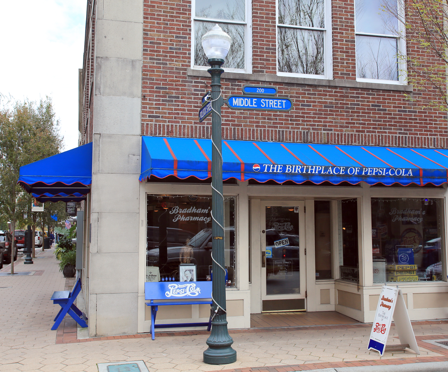
NANTICOKE, MD Day 3.  A surprisingly beautiful day, sunny and warm.  We drove to the Chamber of Commerce in downtown Salisbury, which is simple and convenient, since everything is very close together.  There was plenty of parking on Main Street, so I quickly walked in to get a free map and phone book.  The map helped a lot, since in the 19 years since my last visit, roads have been reorganized with much focus on routing people to the beach, or so it seems.  The term "Ocean Gateway" is used to denote roads across town that are part of this pathway.  It takes a concerted effort to wind your way to Old Ocean City Road, to which we returned to get photos in better light.  Without this extra effort, one easily gets routed to the Ocean Gateway and the new Ocean City Road.

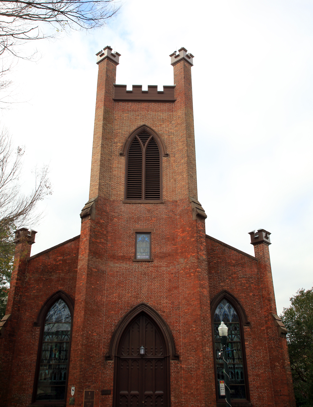
But our first stop after getting the Salisbury map was to North Division Street.  There is another road named Church Street, but it seemed to me that North Division Street could easily be called by that name since there are so many beautiful old churches located there.  And these buildings are in outstanding condition.  One very large grey stone church apparently has been bought by an evangelical inter-denominational group and renamed Faith Community Church.  This is also an historic area where Francis Makemie planted one of his Presbyterian churches on his mission trips down from Philadelphia in the late 17th and early 18th centuries.

Bethesda Methodist Church Imposing Exterior
How Large Those Steps Seemed As a Child
Building Cornerstone 1922

Bethesda Methodist Church Interior Viewed from Entry
Interior Viewed from Balcony

Chancel Area

Leslie Swift and Kathy Blackburn

Sandra Mills and Peggy Hastings

Faith Community Church

Wicomico Presbyterian Church

Front View of Wicomico Presbyterian Church
On prior trips I had been told that this part of town had become run down, but quite the opposite is the case.  There are many old homes converted into professional offices as well as being renovated for modern residences.  It is truly a beautiful place in warm autumn lighting.
View Down Any Street Off North Division Street
I primarily wanted to show Betty the church that I attended in the 1950s, Bethesda United Methodist Church.  Like most of the other churches in the area, Bethesda has purchased and converted an adjacent house to use for office space.  These are very nice two or three story houses with masonry fireplaces and beautiful stairways.  When I got to the church office I was already accompanied by one of the local members whom we had met outside.  She had come to deliver some items and showed us in.  I introduced myself and told of my history with the church.  This lady, Peggy Hastings, asked about our visit, and when I told her of yesterday's stop at the cemetery, she inquired about my grandparents, who had also been members there.  When she heard the surnames Parker and Farlow, she exclaimed that we were family because those were also in her genealogy.  I was a bit stunned, and she virtually adopted me on the spot, taking down my email address to keep in touch.  She and the church secretary, Sandra Mills, showed us into the sanctuary and worked with two other helpful members, Leslie Swift and Kathy Blackburn, to get the lights turned on, since it was quite dark even with lights on.  I was able to get some beautiful photos nevertheless.  Do wish I had lugged my tripod along to help with the low lighting, but perhaps on my next trip.

It was hard to pull away from this warm family reunion, but this was our final day to get photos in this great sunlight.  By now it was time for some lunch, and I wanted to see how the Wicomico River looked downtown, since it had been an eyesore when I was a child.  We ate at the Brew River near West Main Street.  I was very pleasantly surprised to see how nice the river looked.  The area where the large tug boats serve the Chesapeake Shipbuilding plant was well kept now.  After lunch we drove around to the opposite side of the river for some more photos.  Then drove back along Riverside Drive, a beautiful drive.

View of Wicomico River from Restaurant

Panorama View from Restaurant

Panorama View From Across the River
Click on Image to Enlarge
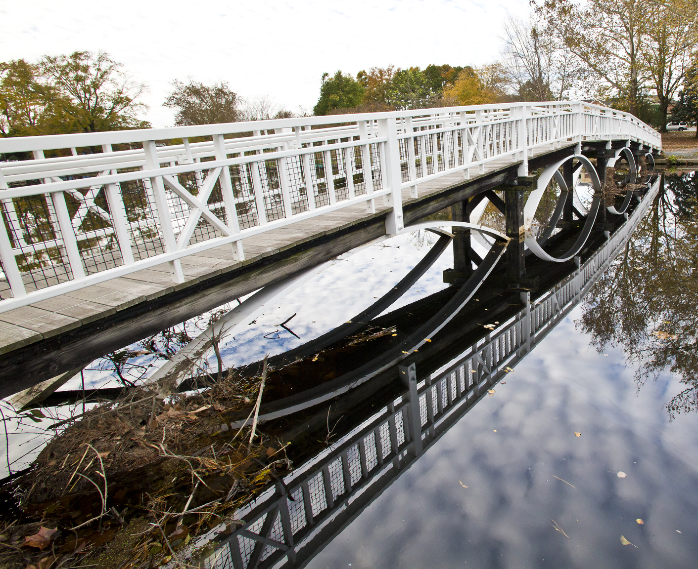
Our next stop was the city zoo and park.  This was always a controversial location since the animal waste from the zoo has gotten into the Wicomico River that passes through the center of the park.  Polluted as it is, with "No Swimming" signs in it, the river seemingly has not dampened the enthusiasm for the park.  Workmen were erecting a large Christmas-tree-shaped frame for stringing lights in preparation for civic celebrations to follow.  The heavy rains of past days left large puddles of standing water everywhere.  Apparently the pollution in this area has not adversely affected the area near West Main Street.  How such a mess turns into a scenic area in less than 100 yards of water flow is a mystery.

Where the Pollution Starts

Then Flows Under the Walk Bridge

Then Accumulates Under The Pretty Large Walk Bridge
What a Pity!

And Continues Under the Walk Bridge Next to Snow Hill Road
From there we returned to Old Ocean City Road.  As we drove along this road, certain houses nearly leaped out from my distant memory, telling me that they were significant but with no further information to say why.  Street names and surnames on signs likewise.  Roads that lead to somewhere once important but too vague now and too little time.

As we arrived at the site of our former residence, we looked over again at the property to the east where Stanford White used to have his farm.  He was always a friendly neighbor, once giving me a ride on his big red tractor.  Now his home has been removed as if it had never been, leaving a few farming tools to rust in the undergrowth.  And the field where he was regularly seen plying his trade on his tractor is overgrown with weeds.

Where Stanford White's Home Used to Be
Abandoned Farm Tools, Even Over to the Left
Click on Image to Enlarge

Farmer Stanford White's Field Viewed Toward Our Former Home
Click on Image to Enlarge
As the day grew darker, we knew it was time to venture back down Nanticoke Road to the campground and prepare for the next day's journey.  The sunset would have been wonderful if a thick cloud bank at the horizon had not blocked the view of the sun's descent.

Sunset Over Nanticoke River

Betty Shoots the Sunset
  
Towboat Moving Cargo in Last Light